Pattani River Basin Network
Background:
Pattani river basin covers 3,805.65 km2 in Yala and Pattani provinces, the southern part of Thailand. The central and southern part of the basin is mountain chains, while on the northern part Pattani river plain dominate. There are two major mountains, San Kala Khiri and Pilo Mountain, range in the area, which are also a natural borderline between Thailand and Malaysia. Majority of the people, approximately 715,000 people, lives in the Pattani River Basin. Agriculture and livestock are their occupation.
The Pattani River is the longest of all Thai rivers on the Malay Peninsula with a total length of 214 kilometres. The river comprises of Pattani River as the main river, with Yaha River and Nong Chik River as tributaries. It flows from San Kala Khiri River through Bang Lang dam and exits to the Gulf of Thailand. There are two large reservoirs which are Bang Lang Dam and Pattani Dam (Diversion dam of Bang Lang Dam). Average rainfall in the main Pattani river varied from 1,500 – 2,200 mm. per year.
In the past, people in the community had encountered several difficulties including 20 – 25 days redundant flood, no canal management and maintenance over 30 years. Later, people in the areas start their collaboration as Pattani River Basin Network to find solutions for their hometown. The network consists of 4 communities’ water resource management groups which are;
- Ban Piyamitr 3 Community, Be Tong District, Yala Province
- Ban Khuan Community, Muang District, Yala Province
- Ban Pagaharang Community, Muang District, Pattani Province
- Ban Tha Dan Community, Nong Chik District, Pattani

S&T Application and Approaches:
Science and Technology has been introduced and applied to the community for water management planning and water resource restoration which can be categorized into 4 approaches;
- Land survey by using tools such as Map, GPS, Water Chart, Telemetering Station and Modelling, to collect and analyze local information
- Use of data to monitor water situation via www.thaiwater.net, ThaiWater Mobile Application (App Store, Google Play), and Automated Weather and Water Monitoring System (Media Box)
- Water Resource Management to tackle existing difficulties
- Revamp existing natural water sources
- Restore existing water infrastructures such as concrete check dams
- Manage saline-control watergate
- Public-Private-People Partnership (PPPP) meeting on disaster warning
- Disaster warning using radio communication system
- Flood relief plan
- Post-disaster analysis for better recovery
- Survey losses and damages area to identity root of problems and prevent new risk
- In-depth interview with local people
Good Practices:
Public-Private-People Partnership (PPPP) networking for flood crisis operation
in Yala and Pattani province during December 2014
In 2010, Hydro and Agro Informatics Institute (Public Organization) or HAII, Ministry of Science and Technology, Thailand, has started applying the Community Water Resource Management (CWRM) concept to Pattani River Basin Network to exchange knowledge, apply science and technology tools for surveying, collect and analyze data to solve local water management planning and water resource restoration.

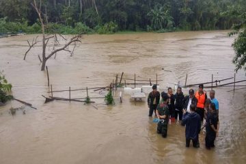
In December 2014, there was a heavy rainfall in 2 provinces of Southern Thailand. The rainfall volume is as high as 3,825 mm. The Royal Irrigation Department (RID) have to urgently drained water from Pattani Dam through Pattani River and 5 irrigation canals which raised up water flow in the system to over 700 cubic meters / second, which is 300 cubic meters higher than the capacity of Pattani dam (the dam capacity equal 400 cubic meters). 650 cubic meters / second of drained water flew into City District of Yala province and caused flooding in Ban Pagaharang Community and Ban Tha Dan Community.

With the support of Pattani River Basin Network in downstream area, flood had been drained into the sea through canals and infrastructures that have been restored and maintained. The flood management has been operated in parallel with drainage watergate. Therefore, the community can increase extra 300 cubic meters / second of drainage capacity to be in accordance with sea level variability.

As a result, flood duration was decreased from 25 days to 3 days and save government’s remedies for farmers up to 800,000 THB.In 2016, RID and Pattani River Basin Network collaboratively launched flood relief plan in Ban Pagaharang Community and Ban Tha Dan Community. The subcanal with approximate 4 – 5 meters width along irrigated canal have been created to increase drainage efficiency and retain flood water during next coming flood crisis.